Providing a benefit for people and the environment
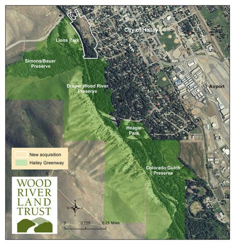
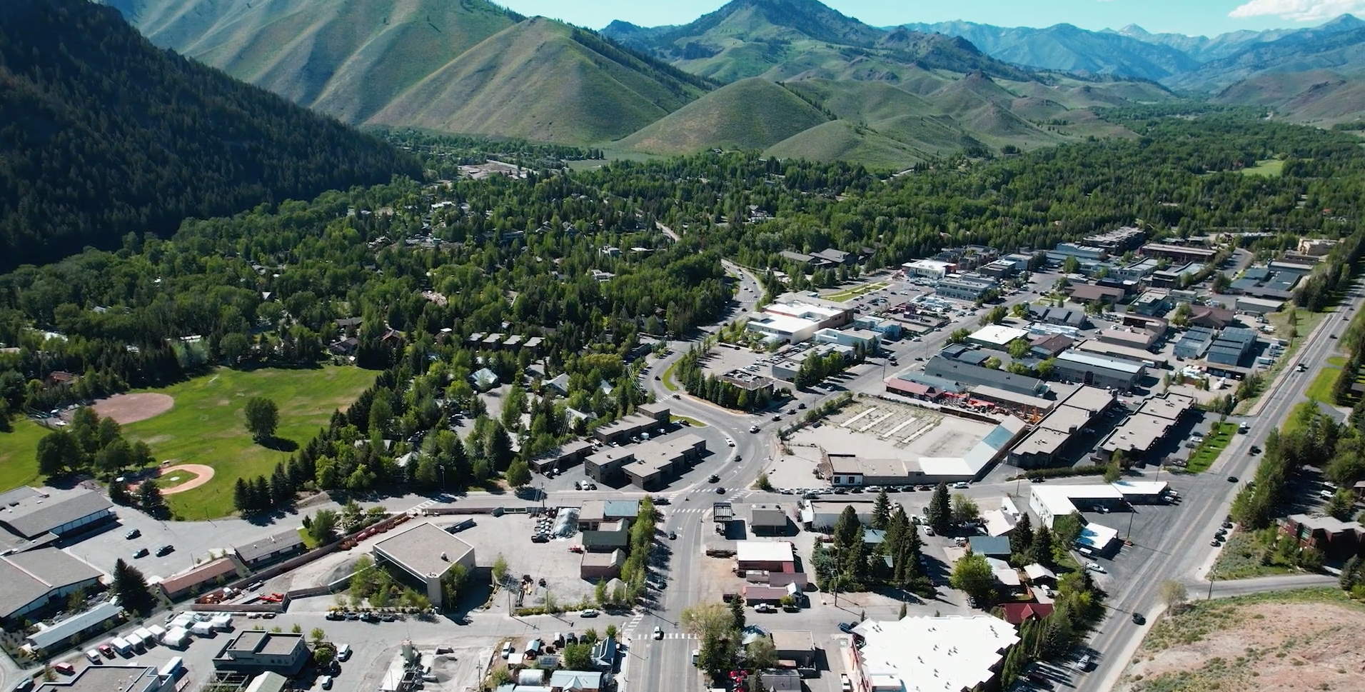
In 2021, the Land Trust acquired a 15-acre parcel at the northernmost end of the Hailey Greenway. The property was purchased to restore and protect the Big Wood River and public access to the Greenway as well as to provide affordable housing for our local workforce.
The Hailey Greenway - Bullion Connection FAQ’s
1. What is currently going on with the property?
The Land Trust held a series of public and neighborhood meetings to gather feedback and input to inform a conceptual design for the property. The goal was to design a project that could protect the sensitive parts of the site (wetlands and floodplain), address surrounding neighborhood concerns, and provide homes that were livable and attractive for our local workforce. Currently we are in a holding pattern until we can get more clarity around the draft floodplain maps that the Federal Emergency Management Agency (FEMA) has been working on throughout the basin.
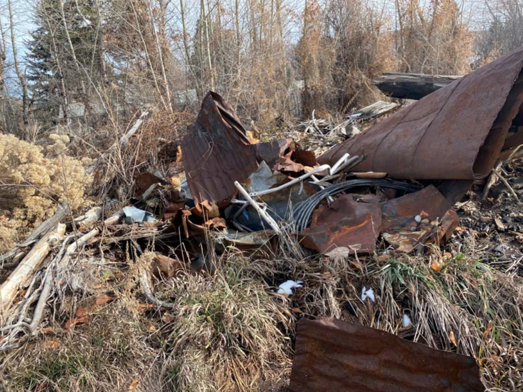
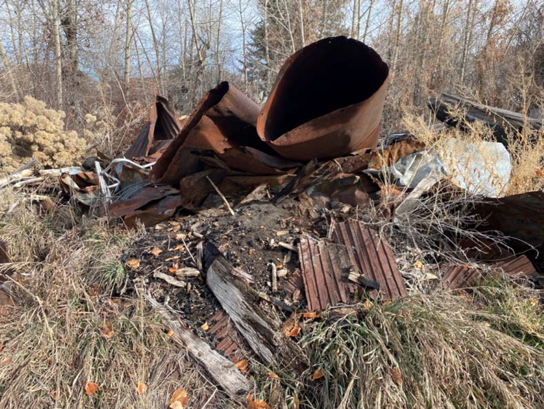
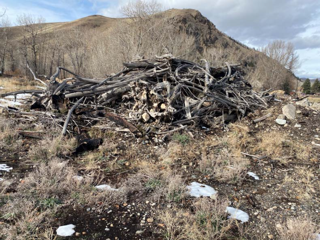
In the meantime, during the Summer 2023, we worked with a local contractor to clean up a number of large piles of tree stumps, wood debris, old building material, and general refuse that have accumulated over the years. The piles have been a concern of neighbors for a long time, especially during wildfire season.
2. What is the Land Trust protecting?
The Land Trust will protect the public trail connection along the river, a public trail connection from Sawmill Road to the riverfront trail, the tailrace slough that provides a buffer behind the homes on Aspen Drive, the 100-foot riparian buffer along the river, and the wetlands and cottonwood forest habitat on the southern end of the property as it abuts the Draper Wood River Preserve.
3. How will wildlife benefit from this?
This project will protect at least 1.5 acres of cottonwood forest that will be contiguous with the forest in the Draper Wood River Preserve. The Land Trust will also be looking to plant native vegetation to enhance the habitat along the river banks. Currently, wildlife can often be seen in the neighborhoods adjacent to the Greenway and use the Draper Wood River Preserve to access the river and the 470-acre protected Hailey Greenway and public lands beyond.
4. What would the housing component look like?
A design has not been completed yet. Once we get clarity around the draft FEMA maps, we plan to work with a non-profit housing partner on the details of the housing component. The design would go through the typical planning and zoning processes and provide opportunity for public comment.
5. Who will be living here?
One of the conditions of the gift was that the property would be deed-restricted for workers earning between 80-150% of the Area Median Income. This has been referred to as “the missing middle,” as they’re households who make too much money to qualify for federal housing assistance, but have been struggling in the current market to find housing they can afford. These are people who work in our community at local schools, law enforcement, doctor’s offices, and local businesses
6. Who are the partners?
WRLT is currently evaluating working relationships with local community housing groups. Details will be provided as they’re available.
7. What is the current condition of this property? Is it a riparian habitat like the Hailey Greenway?
The Property was initially developed in the late 1800’s as a sawmill known as the “Board Mill.” While this property is currently undeveloped, the northern end of this property it has been disturbed in significant ways with fill, rip rap along the river, debris, and piles remain from demolished structures that used to be on the property as well as general waste - rusted metal, burnt wood, a water heater, broken concrete and other trash. Areas further south on the property are less disturbed and are considered quality cottonwood forest habitat - those are the areas the Land Trust is planning on incorporating into the Hailey Greenway. The disturbed area on the northern end of the property is what would be proposed for the community housing effort.
8. Why is this property different from other properties the Land Trust has protected, like the campaign to protect Croy Canyon
Development makes sense in some places, and this is one of those places. This property is directly adjacent to City services and general residential development. The proposed Croy Canyon campground had a number of factors that made it less than ideal for development:
The sensitivity of the emergent wetlands
- The Croy Canyon Parcel is adjacent to a functioning emergent wetland and creek. These types of environments are unique in the Wood River Valley, and provide much needed habitat for wildlife. In the summer, wildlife seek out the refuge of the wetland, and in the winter, it provides forage when other areas are covered in snow. The lack of other significant development nearby provides unfettered access for restoration opportunities and habitat expansion. The cottonwood forest on this property is important for wildlife, which is why the Land Trust will be retaining the majority of the forested area, as well as the river bank. The rest of this site is constrained in terms of restoration potential because of existing sewer lines and the proximity to the China Gardens neighborhood.
The untouched nature of the parcel
- The Croy Canyon Parcel has a natural connection to the floodplain and has not seen the development and disturbance on the site that this property has. While this parcel of land has been undeveloped for many years, it is the site of an old sawmill and has seen lots of fill and disturbance over the years.
The contribution to suburban sprawl
- It is a good example of “orderly growth,” as water and sewer can be tied into existing infrastructure, and the location provides opportunities for walking and biking into the downtown city core.
9. Why can’t this side of the river be restored and connected to the floodplain?
This property has a number of constraints that limit the ability to restore the river’s floodplain on the east side of the river. One is that a sewer line is located within 50-100 feet of the river and runs along the entire length of the parcel from north to south. The other is that removing the fill on this property to restore the floodplain would increase the risk to homes in the China Gardens neighborhood. The only opportunity for floodplain connection in this section of the Big Wood River is the removal of fill at Lions Park on the west side of the river, and reconnecting the floodplain and side channels to the Croy Creek wetlands, as has been approved in the Hailey Greenway Master Plan. The acquisition of this project contributes to the success of that restoration effort, as this parcel contains the east river bank, the river bottom, and a small area of land on the west side of the river as well.
10. How does this project fit with other Land Trust projects?
Looking ahead to the next 30 years, we see the conservation agenda increasing in complexity as our Valley faces challenges like high growth and the impacts of climate change. As our population climbs and the need for affordable housing intensifies, we feel a responsibility to help direct development in the most appropriate areas. Our work includes promoting smart growth principles - concentrating housing around existing infrastructure with a variety of transportation options (walking, busing, biking, and driving) - as a way to balance population growth and environmental protection. With the sensitive areas and public access preserved, the Land Trust believes this can be an example of how a property can achieve both conservation and affordable housing at the same time, and we need to start a larger community conversation around growth planning that integrates planning and zoning with other values and identified needs, such as affordable housing, land conservation and sustainability.
The acquisition of this property also gets us one step closer to the reconnection of the Big Wood River’s floodplain across the river at Lions Park, as the parcel includes both river banks, the river bottom, and a small area of land on the west side of the river as well.
A Visionary Landowner, Donor, and Organization
 This unique opportunity was possible because of two individuals who wanted to demonstrate that conservation and community housing can both be achieved. David Anderson, a former board member of Wood River Land Trust with a long history of supporting conservation throughout the West and nationally, was able to negotiate an agreement with the owner, Mark Caplow for this unique project. Mr. Caplow wanted to contribute to providing a solution to the affordable housing crisis. Mr. Anderson wanted to catalyze a partnership between the Land Trust and local community housing groups to demonstrate that conservation and strategic placement of community housing are not only possible, but also mutually beneficial.
“Our community’s access to nature and open space is why we love living in the Wood River Valley,” says David Anderson. “As our Valley grows, it’s critical to identify the areas that are important for protection, and areas that are appropriate for growth. We need to make sure that the people who work in this Valley and provide essential services for our community can afford to live in town, in safe and attractive homes, where they can raise their families and contribute to the fabric of our community.”
The acquisition was made possible by a charitable gift from David Anderson and a bargain sale from Mr. Caplow. The significance of this 15-acre property is three-fold: it provides community access to the Big Wood River along the river front, it overlaps with Lions Park as the parcel extends across the river, and it provides an opportunity for a community connection to the Hailey Greenway by making the current public trail official and protected in perpetuity.
Not Such A Radical Idea
 This type of development—creating energy-efficient, affordable housing around existing infrastructure with a variety of transportation options (walking, busing, biking and driving)—is not a new idea. In fact, it has a name—Smart Growth. Born decades ago as a solution to urban sprawl, it became a national movement with its own EPA program, guiding communities across the country as they try to find more sustainable ways to balance population growth and environmental protection.
The EPA’s 2017 Report, Smart Growth Fixes for Climate Adaptation and Resilience, contributes to a growing body of evidence that smart growth can reduce carbon emissions, and protect air quality by compact, energy efficient development around existing infrastructure that reduces the heavy carbon emissions of long commutes in vehicles. The report also recommends denser, connected development to reduce land disturbance and storm water run-off, restoration of natural river floodplain to prevent unwanted flooding, and restoration of wetlands and riparian forest cover to protect water supplies in the face of drought.
Elaine Clegg of Idaho Smart Growth who is advising the Land Trust says that the key to success is the “triple bottom line,” including a “strong economy, a healthy natural environment, and happy people.”
The Triple Bottom Line: Environment. Economy. People.
The Land Trust believes that this will be a great example of how a single property can achieve both conservation and affordable housing at the same time, and we need to start a larger community conversation around growth planning that integrates planning and zoning with other values and identified needs, such as affordable housing, land conservation and sustainability. According to Keri, sustainability needs to include consideration of wildlife habitat, migration corridors, habitat for sensitive species, water resources, river health, preservation of wetlands, groundwater and aquifer replenishment, preservation of agricultural land, open spaces, and public access to all these resources. The Land Trust hopes to keep these aspects of sustainability in the forefront of future community conversations about housing.
“You can try to limit growth, but it’s going somewhere,” says Clegg.
The Land Trust sees this as an opportunity to influence how and where that growth goes to benefit the people and the environment. For those who think this is outside the Land Trust’s wheelhouse, Keri reminds us that the land trust movement came about in the early 1980s to protect agricultural land and open space that was being bought up and turned into subdivisions and housing developments.
Despite the common belief that preservation and development are often on opposing sides, the Land Trust and the people who make our work possible, believe in a brighter future. This project represents a new path that moves away from siloed-thinking towards a way of thinking that emphasizes the connectivity of people with the surrounding environment, the climate, as well as our interconnectedness with each other.
“We’ve always been in the business of the triple bottom line,” says Keri. “Environment. Economy. And people.”
Have More Questions or Comments?
Please use the comment form below and we will get back to you!
